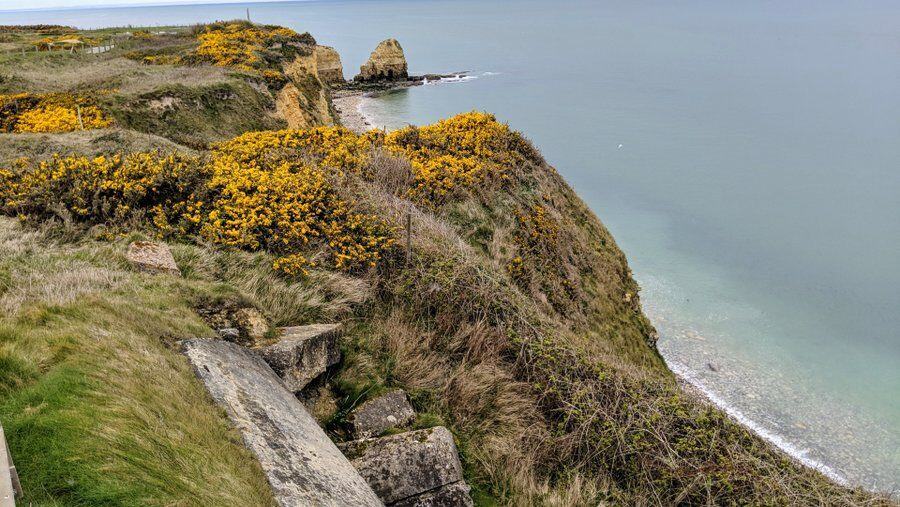
Pointe du Hoc is the famous cliff promontory at the western edge of Omaha beach, that was heroically scaled and overrun by US Rangers on the morning of D-Day, June 6th 1944. Now it is a battlefield and memorial site.
The History
D-Day planners were particularly worried about the battery of 6 x 155mm guns on Pointe du Hoc on the cliffs at the western end of Omaha Beach. Not only did they cover the approaches and landing points on Omaha, they could reach Utah Beach too. It had to be neutralised right at the start of the invasion.
The site could be bombed and shelled, but the only way to ensure the guns were destroyed, especially those in the concrete casements, was to do it by hand, That meant sending in special forces.
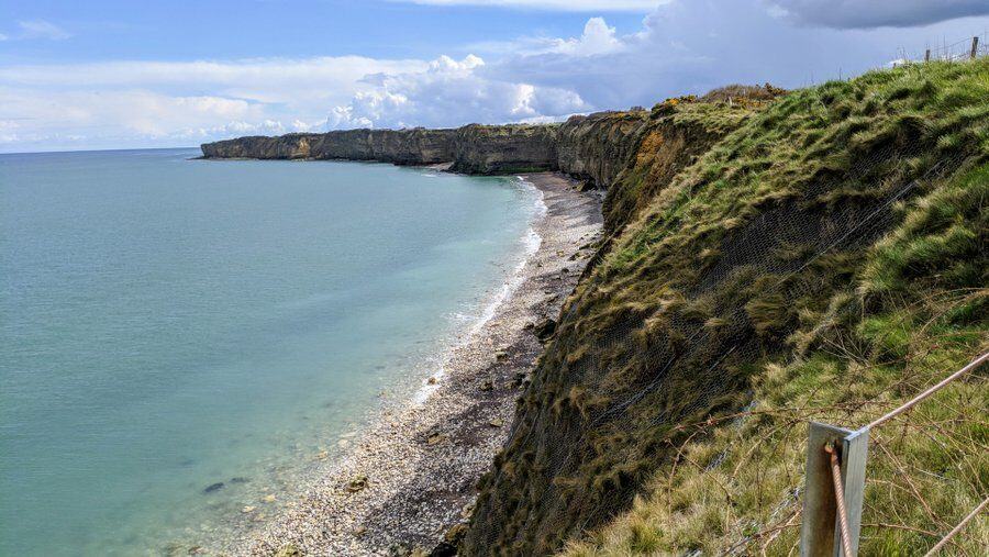
Easier said than done. The site was heavily defended with minefields, barbed wire, trenches (and, as it turned out, tunnels), plus mortars & machine guns in concealed or fortified (or both) positions. This was nearly all concentrated on the land side of the site, where paratroops or ground forces would attack. On the sea side, the site was naturally protected by 100ft cliffs rising above a narrow shingle beach. Nobody would be mad enough to come that way…
The Plan…
Attack from the sea!

The U.S. 2nd and 5th Ranger Battalions were given the job, under the command of Lieutenant Colonel James Earl Rudder.
The idea was that three companies from the 2nd Rangers would lead the assault in a dozen landing craft. Using a combination of ladders, ropes and rocket powered grappling hooks, they would quickly surprise the German garrison and destroy the guns. On their signal, the main force, comprising 5th Ranger battalion and the remaining companies of the 2nd, would follow in behind and the combined force would secure the site and cut the road to Omaha beach to disrupt German counter-attacks.
If the signal didn’t come, the main force would land on Omaha Beach and approach/attack from the land side.
What actually Happened…
A strong easterly current and poor light caused the landing craft to approach the wrong promontory. When they realised their mistake they had to turn right and work their way along the coast slowly against the current. As a result they lost the element of surprise and landed under fire, while soaked and seasick, some 40 minutes late.
When they finally got to the shore, they discovered the spray from their rough sea journey had also soaked their ropes making them too heavy for the rockets. Most fell short of the cliff top. On the plus side, the naval bombardment had caused some parts of the cliff to slip, leaving rubble ramps at the base of the cliff and a gulley above. This made it easier to scramble up with ropes and ladders. When they got to the top, they fanned out to attack the gun emplacements, only to discover there were no guns. The guns had been removed and in some casements replaced with telegraph poles as dummies.
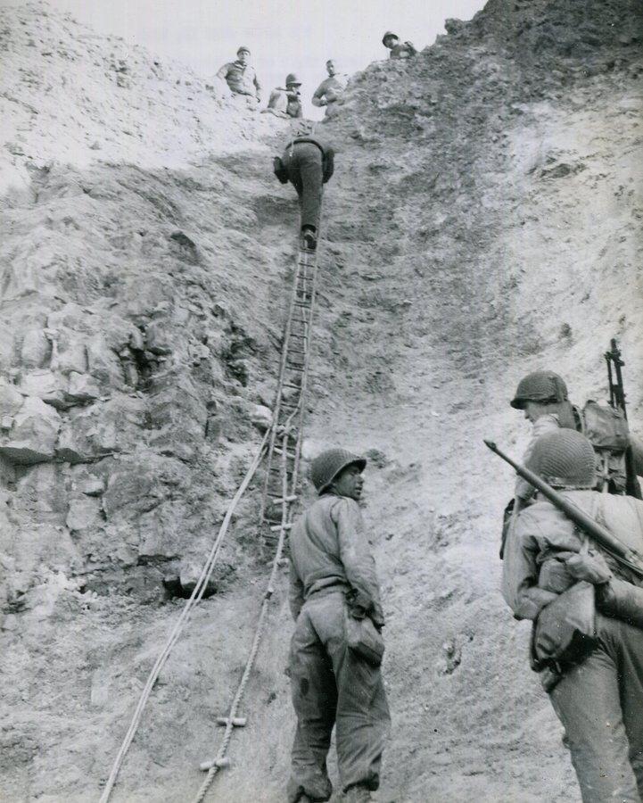
Under continuous fire and moving from crater to crater, the Rangers moved inland and soon discovered the missing guns unguarded in a field. They crippled them with thermal grenades, and set about defending the site from counter-attack.
Things, as we know, didn’t go so well on Omaha Beach and it took the main force of Rangers some time to just get off the beach, before running into heavy resistance on their way to Pointe du Hoc. One group of 23 men from the 5th Rangers did manage to get through in the evening of the 6th, three very lost Paratroopers from the 101st Airborne joined them, and a reserve 2nd Rangers platoon came in by sea, but Rudder had lost about 50% of his men. Nevertheless, short of ammunition and other supplies, the men of D, E & F Companies, 2nd Rangers continued to hold Pointe du Hoc against heavy attacks, for another 36 hours until the main force arrived. Of 225 US Rangers* who left the boats to attack Pointe du Hoc, 90 were still alive when relieved on the morning of June 8th.
What’s there now?
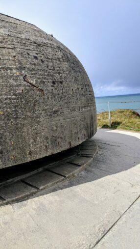
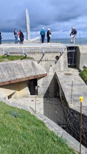
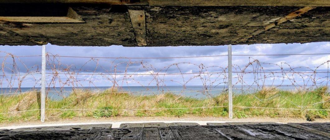
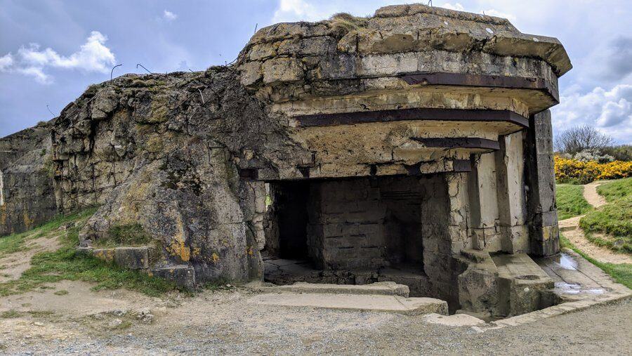
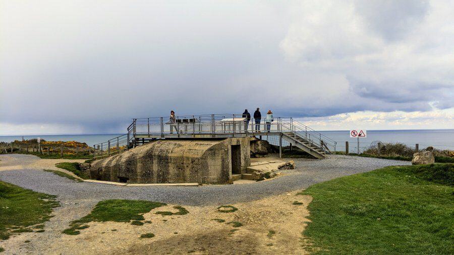
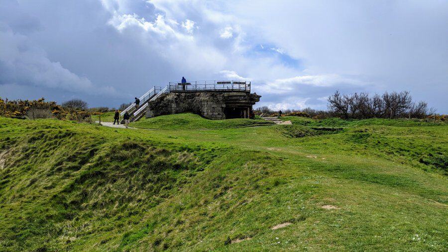
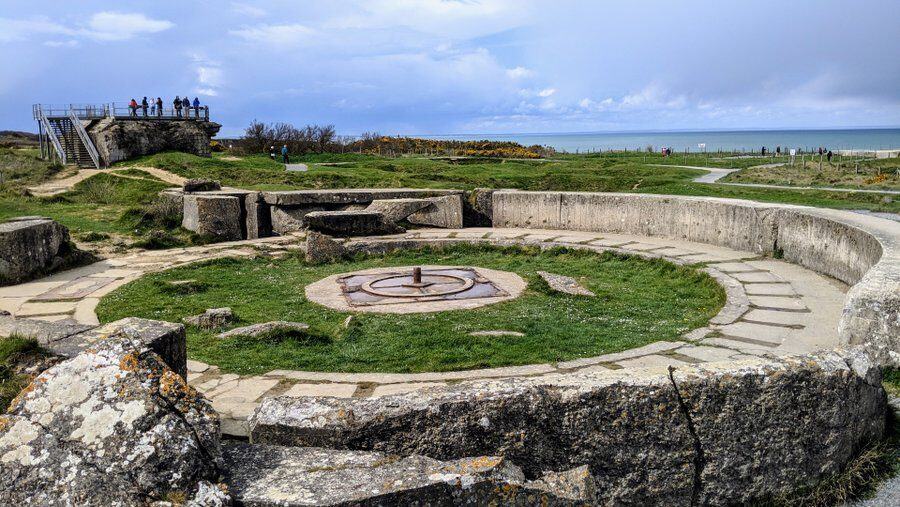
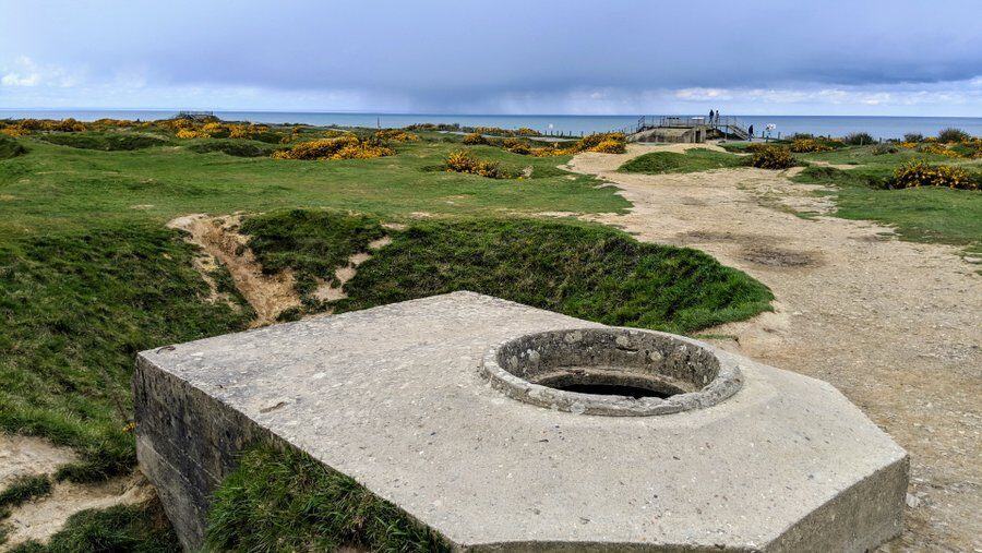
Well, astonishingly, 75 years later, the whole site is little changed from 8th June. The guns aren’t there, but then, they never were! But the casements and gun pits are – some heavily damaged. The observation bunker on the cliff edge is still intact. You can wander into it, and peer out of the slit and read the remembrance plaque to the Rangers inside.
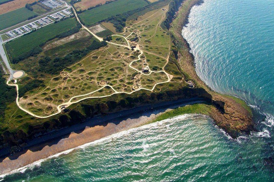
The most striking thing about the site is the craters. The whole landscape is covered in huge bomb & shell craters. It gives you an idea about the intensity of the bombardment, and an idea of how intense the fighting was on the ground too. For example, you can see the murderous 20mm AA gun emplacements, and the craters that individual Rangers used for cover while trying to attack them.
* Not every man was a US Ranger. Lt Colonel Thomas Trevor was a British Royal Commando who had trained the Rangers in climbing techniques. He joined them on the assault. The Rangers also acquired three US paratroopers from 101st Airborne who had been badly mis-dropped on the shoreline a few hours earlier.
D-Day Normandy Posts
Declaration: The site is a memorial site, open to the public and free to enter. I was visiting on a self-driving press trip as a guest of the Normandie and Calvados tourist offices.
Factbox
Website:
Pointe du Hoc Monument
The Pointe du Hoc Rangers monument is a simple granite pylon positioned on top of the German concrete observation bunker with tablets at its base inscribed in French and English.
There is free car parking and a Visitors Centre which is open 9.00am – 6.00am April 1 to September 30, and 9.00am – 5.00pm the rest of the year.
Getting there: Pointe du Hoc Ranger Monument
14450 Cricqueville-en-Bessin
France
Take the D514 road between Grandcamp-Maisy and Vierville-sur-Mer at Omaha Beach, the access road to Pointe du Hoc is signposted at the roundabout at Le Guay.